

The phrase “failing to plan is planning to fail” is something we used a lot back in my software engineering days. It still holds true for planning homesteads, farms, plots of land… almost anything. A well-thought-out layout can save you time, energy, and resources in the long run. There’s a myriad of of considerations to ponder when you do your farm and homestead planning for self-sufficiency & self-reliance (yes, there is a difference).
Practice Makes Expensive Perfect
We had several shots at this in the last decade or two. Every iteration is time consuming and, of course, has costs involved. There are things like buying trees, seed, pipes, shade-net, etc. Naturally, we try to limit costs as much as possible, because if you really plan properly, things can support one another. It’s important to save money and time. Money is expensive 🙂 Time is free, but totally valuable.
We walked that specific tight rope several times. In the end, we have learnt enough to write three books about it. We still miss things, we still forget and overlook key issues in our plans because every site has its own wind, rain, sun, size, distances, aspects, slopes, smells, risks, opportunities, threats…
Before settling down on this wild, untamed and challenging piece of land, we underwent a bit of schooling through:
- Urban homestead in Cape Town – treated organically, using rainwater to grow our plants and raise our hens. We could do here no butchering, but we had oodles of eggs and rain water thanks to the ample winter season precipitation there.
- Some rented land on a large 7000ha Groot Karoo farm in the arid Matjiesfontein area. The land owner was fairly bitter and stuck in the conventional Ag (or lifestyle ‘farming’) mindset. Any attempts to harvest rain, soak it in via swales or protecting crops with shade-net were met with hostility. We had to plan around this by employing low impact solutions to get our goats, hens and food trees to thrive.
- The first piece of agricultural land we owned in Tulbagh was extremely flat with zero elevation changes, soaked winters and boiling summers. This place grew almost all of our nutritional needs, and is one of my favourite annual and perennial vegetable garden memories. On a single acre, we managed our own water, vegetables, electricity, security, goats, chickens and extreme winds.
- While finding our ideal land in the Klein Karoo wilderness, we again rented land in the Groot Karoo. Being temporary, we did not set up new features there, but managed our livestock during the transition to produce the best they could. It gave us almost a year to think, plan and look at exactly what was we needed to do.
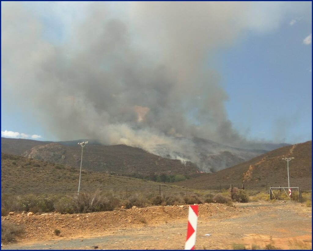
- Finally, here at Windhelm, we are living the toughest, most challenging times with the largest rewards. The work is harder than ever, and the land keeps beating us with a stick, and to make things work here, we had to employ a mindset of “overcome to succeed”. Rains are few, but when they fall, they fall hard and out of control. Summers are prohibitively dry and hot. Winters are freezing. Animals and plants need to be ready for this place, and there is no conventional Ag here that could succeed without ruining the veld for aeons to come. We are still finding the right balance and timing of everything and everyone here.
Proximity is almost the entire thing…
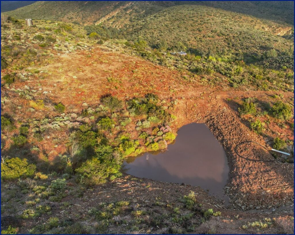
Distance isn’t just a utopian notion; it’s a sensible one. Your home, animal areas, vegetable gardens, and natural resources like water should be strategically placed during your farm & homestead planning phases. Too far apart, and you’ll waste time and energy trekking between them. Too close, and you might have to deal with issues like odor, pests, or water contamination. If you’re on flat land, you can employ swales to hold water and sink it in, or make it available to trees and food gardens. In our case, there’s almost not enough flat land. Everyone visiting sees it as a problem or limitation. Initially, we did the same, but now we realise how powerful these hills are. They can store water high enough to push down 200-400kpa of pressure. The hills produce shade in the hottest months, and they are immovable objects to the baffling winds we get here. Unfortunately, we lived here for a year before we realise exactly where to put things to get the right balance. Too much shade and the solar panel charge rates are affected, for example.
We are now planning our permanent site to set up a perfect homestead on this farm, and we taking everything into account. Everything. I still think we’ll be missing something. One issue is that our favourite, most logical spot is situated higher on the land, and getting water to it from the well is going to be a challenge. Using solar angle apps, known parameters and data points from the weather station, we can now determine our prevailing wind directions, hot and cold season. The mountains in the west have this little peak that will give us a bit of earlier shade in the summer, but the winter sun will linger longer. The south-eastern hills will help block the strong gusts in summer. We cannot avoid the colder NW wind, but it’s short-lived, and the remedy is a cottage with little glass on the north (both good to block hot sun, and cold ingress). How about flood waters? Hailstorms? Frost? Geothermal cooling…
Animal areas need to be downwind of home area, but they also deserve cooling and warmth. They have run-off, which is great for gardens and bad for human dwellings. They have smells. We need to feed them, deliver feed to them and graze them. How they move, where they move to and how we get to them is key. The same goes for vegetable gardens. They can thrive where the elements are balanced, but where permaculture edges exist. Gardens should be close to home, managed daily, and monitored for pests and harvest times. Where we create fertiliser, compost and harvest things matter. Is there enough water pressure to supply water to the gardens and animals? Fit these things together like a puzzle, and consider the permaculture zones and sectors carefully!
Proximity is the first on this list, because I really think it is the one thing that caused me the most frustration and exhaustion in accomplishing mandatory daily tasks.
Roads, before we forget.
Access roads are the veins of your land, facilitating the flow of building materials, feed, animals and people. Make sure they are weather-resistant and well-maintained. We should also consider the distance between key areas when laying out roads, as should the impact of weather like mudslides or flooding.
Never have we been affected by rain as much as here. We need every drop, which means every rain ‘warning’ we get from the weather service is a fierce, bittersweet experience. If it wasn’t for the internal roads, we would not worry at all. Fortunately, the western cape is managed by a fairly functional government that still works for its people, and they tend roads to when they are affected. However, there’s two types of roads to take into consideration during your planning:
Internal and external roads. Public and Private.
Someone else manages the external, public roads, using your tax money. They are important, and they can take a lot of damage if the storms are bad enough. Fortunately, a result of having millions of tax coin behind them, means they got proper planning and thorough construction (well, mostly).
The community, us, our neighbours often get locked into our farms because of roads being washed out, or turned to mud. This is very temporary, and within hours or days, the municipality sorts it out. It’s comforting to know that “we are not alone”, in this regard.
The internal private roads, however, are a challenge by itself. Us simple land owners design them for simple use, employing best practices and best efforts. They succumb to floods, more than we want to admit. Twice now have we spent over R6000 (ZAR) on machinery to repair the drifts, because when they are washed out, we can’t leave. Ok, we can technically leave but with great effort. On some drifts, 4×4 low-range can stand victorious… on others, not so much. While friends and neighbours stand together, sharing rides and transport, it remains difficult carrying 40kg bags of feed half a kilometer when you simple cannot get to the animals by vehicle.
Planning roads involve a few simple considerations. Water flow, land stability and distance. We have taken on a new stance lately. The old 1800s wagon trails seem to be on the correct contours already, and follow the best slopes. They had to get it right with those methods of transportation. Why would be play smart-ass, and carve out new roads everywhere, adding to the destruction of natural veld?
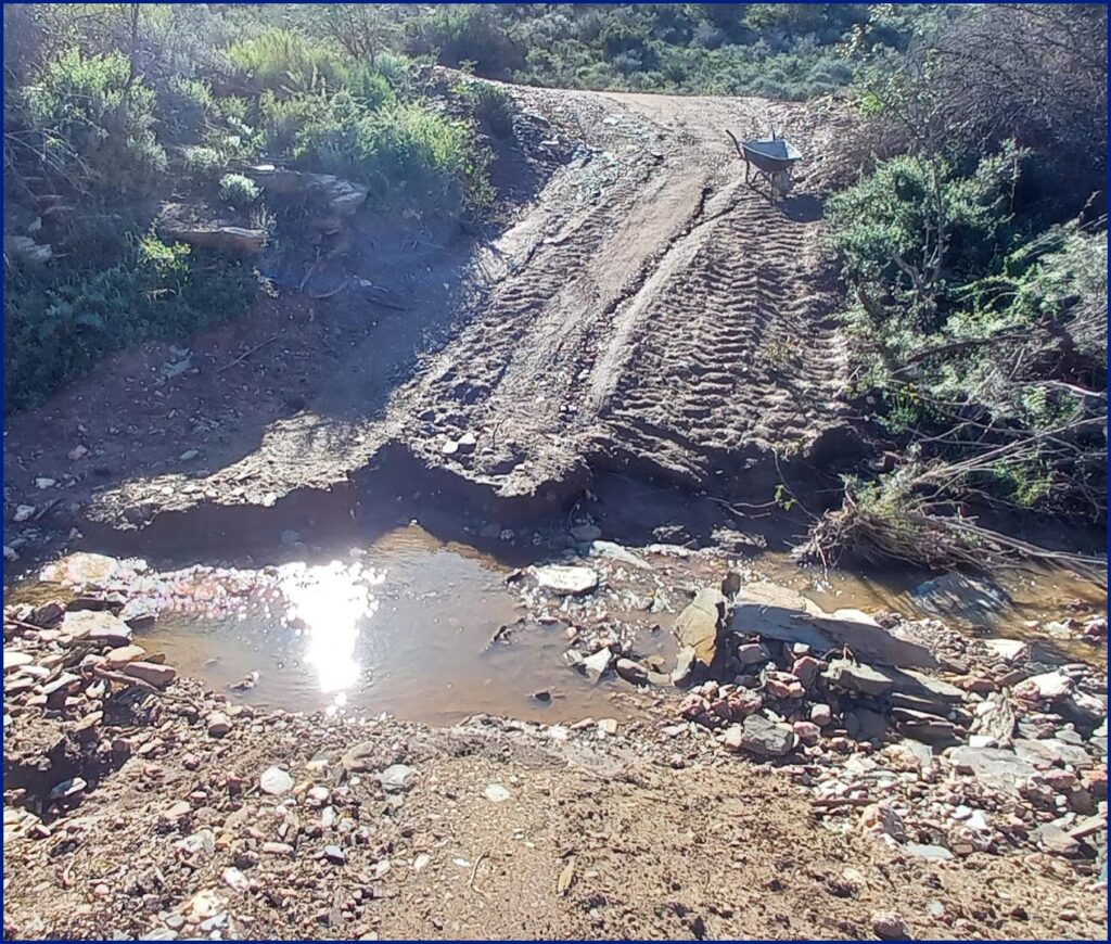
Grade your roads correctly, allowing water to run off before it erodes the road. Contours, heights, distances, angles, flood flow, wind, security, fire access and exit, emergency, bypass areas, rerouting options… think about all of this.
TLDR
Draw maps, write notes, collect data, consider everything, every smell, every feature. Plan. Plan. Plan. Then be prepared to adapt, because you will still miss half of the components.